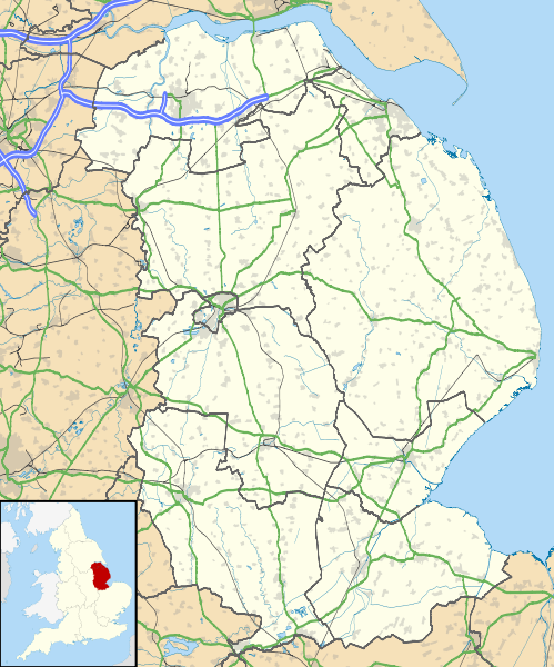
Archivo:Lincolnshire UK location map.svg
Apariencia

Tamaño de esta previsualización PNG del archivo SVG: 499 × 600 píxeles. Otras resoluciones: 200 × 240 píxeles · 399 × 480 píxeles · 639 × 768 píxeles · 852 × 1024 píxeles · 1704 × 2048 píxeles · 1086 × 1305 píxeles.
Ver la imagen en su resolución original ((Imagen SVG, nominalmente 1086 × 1305 pixels, tamaño de archivo: 2,71 MB))
Historial del archivo
Haz clic sobre una fecha y hora para ver el archivo tal como apareció en ese momento.
| Fecha y hora | Miniatura | Dimensiones | Usuario | Comentario | |
|---|---|---|---|---|---|
| actual | 19:01 26 sep 2010 |  | 1086 × 1305 (2,71 MB) | Nilfanion | {{Information |Description=Map of Lincolnshire, UK with the following information shown: *Administrative borders *Coastline, lakes and rivers *Roads and railways *Urban areas Equirectangular map projection on WGS 84 datum, with N/S str |
Usos del archivo
Hay más de 100 páginas que enlazan con este archivo.
La lista siguiente sólo muestra las primeras 100 páginas que enlazan con este archivo. También puedes consultar la lista completa.
- Alford (Lincolnshire)
- Allington
- Ancaster
- Bardney
- Barkston
- Barrowby
- Bassingham
- Baston (Lincolnshire)
- Bicker
- Billingborough
- Billinghay
- Binbrook
- Blyton
- Bourne (Lincolnshire)
- Bracebridge Heath
- Branston (Lincolnshire)
- Brant Broughton
- Brookenby
- Burgh le Marsh
- Butterwick
- Caistor
- Carlton-le-Moorland
- Castillo de Bolingbroke
- Catedral de Lincoln
- Coningsby Airfield
- Cranwell RAF College and Airfield
- Crowland
- Deeping St Nicholas
- Digby
- Donington (Lincolnshire)
- Dunholme
- Dunston (Lincolnshire)
- Eagle (Lincolnshire)
- Fishtoft
- Fiskerton
- Fleet Hargate
- Folkingham
- Foston
- Friskney Eaudyke
- Fulstow
- Gainsborough (Lincolnshire)
- Gedney Drove End
- Gedney Hill
- Gosberton
- Grainthorpe
- Great Gonerby
- Greylees
- Grimsby
- Harlaxton
- Harmston
- Horncastle
- Huttoft
- Ingham (Lincolnshire)
- Keelby
- Kirton (Lincolnshire)
- Langtoft
- Leasingham
- Legbourne
- Lincoln (Reino Unido)
- Long Bennington
- Long Sutton (Lincolnshire)
- Louth (Lincolnshire)
- Mablethorpe
- Manby
- Mareham le Fen
- Market Deeping
- Market Rasen
- Marshchapel
- Nocton
- Normanby-by-Spital
- North Hykeham
- North Kelsey
- North Scarle
- North Somercotes
- North Thoresby
- Northgate
- Old Leake
- Pointon
- Potterhanworth
- Quadring
- Reepham (Lincolnshire)
- Rippingale
- Risegate
- Ropsley
- Ruskington
- Saltfleet
- Scunthorpe
- Spilsby
- Stickney (Lincolnshire)
- Sturton by Stow
- Sutterton
- Sutton Bridge
- Sutton St James
- Swinderby
- Swineshead
- Tealby
- Tetney
- Thurlby
- Timberland (Lincolnshire)
- Tydd St Mary
Ver más enlaces a este archivo.
Uso global del archivo
Las wikis siguientes utilizan este archivo:
- Uso en ar.wikipedia.org
- Uso en azb.wikipedia.org
- Uso en bg.wikipedia.org
- Uso en ceb.wikipedia.org
- Uso en de.wikipedia.org
- Uso en el.wikipedia.org
- Uso en en.wikipedia.org
- Sausthorpe
- Boston, Lincolnshire
- Crowland
- Woolsthorpe Manor
- Sutton Bridge
- Grantham
- Harlaxton Manor
- Brigg
- Cleethorpes
- Sleaford
- Woolsthorpe-by-Colsterworth
- Bolingbroke, Lincolnshire
- Scopwick
- North Thoresby
- Read's Island
- Grimsby
- Cranwell
- Scunthorpe
- Whitton, Lincolnshire
- Woolsthorpe by Belvoir
- Swallow, Lincolnshire
- Saltfleet
- Skegness
- Epworth, Lincolnshire
- Gainsborough, Lincolnshire
- Barton-upon-Humber
- Spalding, Lincolnshire
- Horncastle
- Louth, Lincolnshire
- Bourne, Lincolnshire
- Stamford, Lincolnshire
- Haddington, Lincolnshire
- Alford, Lincolnshire
- Crowle, Lincolnshire
- Market Rasen
- RAF Waddington
- Scartho
- RAF Scampton
- RAF Digby
- South Ormsby
- Salmonby
- Tathwell
- Ancaster, Lincolnshire
- RAF Coningsby
Ver más uso global de este archivo.
